Transform Existing Conditions Into Intelligent Digital Assets
At Civistruct Integrated Systems, we leverage cutting-edge technology to convert real-world environments into accurate digital representations. Our Scan-to-BIM and UAV (Drone) Data Processing services enable architects, engineers, contractors, and facility managers to work with high-precision data throughout the project lifecycle — from planning and design to construction and asset management.
Scan-to-BIM Services
Accurate As-Built Models for Smarter Decision-Making
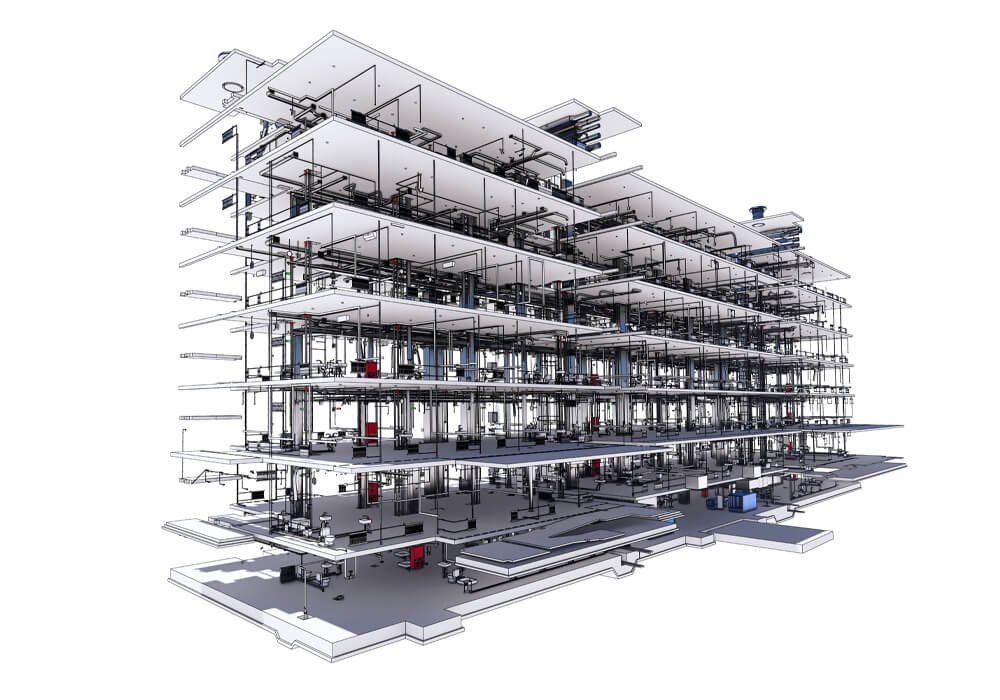
Our Scan-to-BIM workflow utilizes high-resolution 3D laser scanning technology to capture detailed as-built conditions of buildings and infrastructure. We transform point-cloud data into structured BIM-ready Revit models aligned with industry standards and project requirements.
What We Deliver
- Detailed Architectural, Structural & MEP Models
- Asset Tagging and Space Classification
- Model Deliverables in Revit, IFC, or Navisworks
- LOD (Level of Detail) Compliance — LOD 100–500
- Existing Conditions Documentation
Ideal for
- Renovations & Retrofits
- Heritage preservation
- Facility upgrades
- Clash detection coordination
- Digital twins and lifecycle management
With Scan-to-BIM, teams gain confidence in their design assumptions, reduce costly errors, accelerate workflows, and improve coordination on-site.
UAV Data Processing Services
High-Accuracy Aerial Intelligence for Every Project
Our UAV (drone) mapping solutions capture terrain, structures, and infrastructure from above — delivering geospatial data with unmatched speed and precision. Using advanced photogrammetry and LiDAR (where applicable), we generate accurate 2D and 3D datasets for analysis and planning.
We Provide
- Orthomosaic Mapping
- Digital Elevation Models (DEM / DTM / DSM)
- 3D Terrain & Surface Models
- Construction Progress Monitoring
- Aerial Inspections
- Volumetric Analysis for Earthworks
Industries We Support
- Civil infrastructure
- Energy & utilities
- Construction & mining
- Real estate development
- Transportation & logistics
Aerial data drastically reduces site visits, increases safety, and accelerates decision-making.
Benefits of Civistruct Scan-to-BIM & UAV Data Processing
Reduced Design Risks
Accurate documentation minimizes rework and clashes.
Improved Project Coordination
Precise geometry supports better collaboration between disciplines.
Accelerated Timelines
Rapid data capture speeds up design and planning stages.
Enhanced Safety
Remote data collection mitigates human exposure to hazardous environments.
Cost Savings
Fewer site visits, better quality control, and informed decisions reduce overall project cost.
Deliverable Formats
We deliver outputs compatible with leading industry tools, including:
- Autodesk Revit
- Navisworks
- Civil 3D
- Recap Pro
- IFC / DWG / DXF
- GIS formats (GeoTIFF, SHP)
Why Choose Civistruct
- Certified BIM professionals
- Full lifecycle digital workflows
- High-precision scanning hardware
- Advanced photogrammetry & LiDAR processing
- Custom standards and templates
- Proven experience across East Africa
We don’t just capture data — we turn it into actionable project intelligence.
Leverage the power of reality capture and aerial intelligence to enhance your next project.
Contact our team to discuss project requirements, pricing, and data delivery options.
Digitize your built environment with confidence. Build smarter with Civistruct Integrated Systems.